| Updated: Feb. 10, 2023 | |||
 The Bay Area’s most gorgeous hike and ride – along the Ridge Trail through Marin to Fort Baker. The Bay Area’s most gorgeous hike and ride – along the Ridge Trail through Marin to Fort Baker. |
|||
| Maps: | 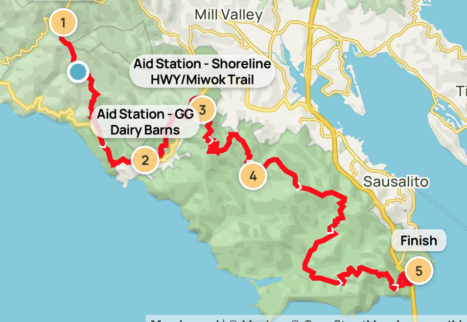 |
Bay Area Ridge Trail
Hiking map for 2023 Ridge to Bridge (coming) |
|
| You can download detailed maps and route information at: The sponsor’s webpage. | |||
| TICK WARNING – We were informed of a ‘tick bloom’ on Mt. Tam, in May 2018. If your assignment takes you anywhere where ticks might be a problem, PLEASE TAKE PRECAUTIONS! | |||
| Date: | Saturday, April 30, 2022 | ||
| Website: | RidgeTrail Events Page | ||
| Activity Description: | Our second public service event of the calendar year; The Ridge to Bridge (hike, run, mountainbike, horseback) event is sponsored by the Bay Area Ridge Trail Council and follows the Ridge Trail (of course) from Pantoll Campground south to Fort Baker. The participants gather at Fort Baker (the location of net control) and are transported by bus to the various stages of different lengths (the longest starts at Pantoll Campground, the shortest from Muir Beach.) There will be 300-500 participants; radio comms will be staged at 5 rest stops including net control. Ten to 14 operators will be needed, depending on the need for shorter shifts . This early in the year, windy and rainy weather may be encountered. The event starts before dawn (about 5:30) and concludes before sunset (about 1830.) Please let us know early if a shorter shift will be necessary to meet your schedule. | ||
| What will be expected: | You will arrive at your assigned location at your assigned time. See duty assignments for your time. You will check in with net control and report your status. You will identify yourself to the event personnel at your site. You may expect to relay messages between the event personnel and the start. You may be asked to render assistance to the event personnel. Some operators may be asked to sweep participants from the course or be asked to hike with event personnel while they are sweeping. Radio hikers should plan to report 15 at least minutes before your bus departs. You will be released by net control depending on where your location is. Please supply your t-shirt size, when signing up. Ridge to Bridge Station Descriptions | ||
| MARS Organizer: | Stan and Pam Witherspoon | pamdwspoon@gmail.com | |
| Pre-event On-the-air Breifing: | Thursday prior to the event at 7:30PM on the 146.700 repeater system | Please send after-event comments to: DEBRIEF | |
| BACKUP CELLPHONES: Pam 916.342.7487 Stan 916.201.9621 ROB 650.866.9078 | |||
| ORGANIZERS CELLPHONES: OPEN | |||
| Ridge to Bridge Station Descriptions | |||
| Download Latest Assignments: 2023 V1 Assignments WILL CHANGE | |||
2023 Assignments V0/ Location / TacticalOperatorCall SignStart TimeFinish Time
| Nets/Repeaters: | ||||
| Primary Frequency: | 147.330 MHz | Plus Offset | PL 192.8 | Mt. Tam West VHF |
| Secondary Frequency: | or 443.250 MHz | Plus Offset | PL 179.9 | Mt. Tam UHF |
| Tactical: | 146.555 MHz | Simplex | ||
| Simulcast System | 146.700 MHz | Minus Offset | PL 203.5 | Big Rock VHF |
| Simulcast System | 146.700 MHz | Minus Offset | PL 167.8 | Mt. Barnabe VHF |
| Simulcast System | 146.700 MHz | Minus Offset | PL 179.9 | Mt. Tamalpais VHF |
| Fort Baker Start / Finish – Net Control | 05:00 | 19:30 | ||
| Fort Baker Start / Finish – Net Control | 09:30 | 15:30 | ||
| Fort Baker Start / Finish – Net Control | 04:30 | 09:30 | ||
| Fort Baker Start / Finish – Net Control | 11:30 | 19:00 | ||
| Fort Baker Start / Finish – Net Control | 05:00 | 15:30 | ||
| Fort Baker Start / Finish – Net Control | 15:00 | 19:30 | ||
| Fort Baker Start / Finish – Net Control(Winlink) | OPEN | OPEN | ||
| Muir Beach near Pelican Inn, drop point for 13-mile hikers | ||||
| Muir Beach near Pelican Inn, drop point for 13-mile hikers | 09:15 | 11:30 | ||
| Muir Beach near Pelican Inn, drop point for 13-mile hikers | 09:15 | 11:30 | ||
| Muir Beach near Pelican Inn, drop point for 13-mile hikers | 09:15 | 11:30 | ||
| Tennessee Valley; lunch stop, endpoint for 6-mile hikers who will be shuttled back to Fort Baker | 07:30 | 14:00 | ||
| Tennessee Valley; lunch stop, endpoint for 6-mile hikers who will be shuttled back to Fort Baker | 07:30 | 14:00 | ||
| Tennessee Valley; lunch stop, endpoint for 6-mile hikers who will be shuttled back to Fort Baker | 08:00 | 10:30 | ||
| Tennessee Valley; lunch stop, endpoint for 6-mile hikers who will be shuttled back to Fort Baker | ||||
| Tennessee Valley; lunch stop, endpoint for 6-mile hikers who will be shuttled back to Fort Baker | 08:00 | 14:00 | ||
| Miwok Trail and Shoreline Hwy (Windy Gap) aid station | 08:00 | 14:00 | ||
| Tennessee Valley | 08:00 | 17:30 | ||
| Tennessee Valley | 08:00 | 17:30 | ||
| Tennessee Valley | 09:00 | 17:30 | ||
| Tennessee Valley (EMT) | EMT | EMT | ||
| Pantoll Campground; starting point for 18-mile hikers and bicyclists | ||||
| Pantoll Campground; starting point for 18-mile hikers and bicyclists | ||||
| Pantoll Campground; starting point for 18-mile hikers and bicyclists | ||||
| Pantoll Campground; starting point for 18-mile hikers and bicyclists | ||||
| HIKER ONE on the 18-mile course, 6:15AM Bus – | 06:00 | TBD | ||
| HIKER TWO on the 20-mile course: 7:00 AM Bus – | 06:45 | TBD | ||
| HIKER THREE on the 20-mile course: 7:45 AM Bus – | 07:45 | TBD | ||
| HIKER FOUR on the 15-mile course: 9:00 AM Bus – | 08:45 | TBD | ||
| 09:30 – 10:00 | TBD | |||
| WE MAY ALSO DEPLOY APRS RADIO-TRACKERS FOR THE HIKE LEADERS ON THE TWO 18-MILE BUSES AND THE CYCLISTS WHOSE BUS DROPS THEM OFF AT Pantoll Campground. If we utilize trackers, Net Control will monitor their progress. | ||||
| Michael K6MLF will be equipped as a SAG and will be a reserve-roamer all the day. Louise, the Bofax R2B captain, wlll be a SAG after her shift, and staged at Four Corners, be available by cellphone. David Pearson at Shoreline will be outfitted as a SAG, and can be deployed from there if necessary. | ||||
| Sweeps will close the course, staying behind the last hikers | ||||
| Please use and respond to your tactical designator | ||||
EMERGENCY TRAFFIC ALWAYS HAS PRIORITY. PLEASE STAND BY UNTIL THE EMERGENCY HAS BEEN HANDLED. |
||||
To sign up as a radio volunteer for this event please send an email with your preferred assignment and the times you are available to: fischer@igc.org